

Terrain refers to the shape of the Earth's surface and can be classified into five basic types: plains, hills, mountains, plateaus, and basins. The distribution and characteristics of these terrain types vary across different regions of the world, resulting in distinct topographic features.
North America is situated in the Western Hemisphere, north of the Arctic Ocean and east of the Atlantic Ocean. It is bordered by the Pacific Ocean to the west and the Atlantic Ocean's Gulf of Mexico to the south.
The continent is almost entirely surrounded by water, with the exception of its connection to Central and South America via the Central American isthmus. North America has a long coastline spanning over 60,000 kilometers, dotted with numerous islands, peninsulas, and bays. Greenland, located in the northeastern part of North America, is the world's largest island.
The topography of North America can be divided into three north-south longitudinal zones. The western part of the continent features tall mountain systems resulting from plate collisions with the Pacific and Antarctic plates, forming the world's longest mountain system known as the "Cordillera."
The Cordillera extends over 15,000 kilometers from Alaska in the north to Tierra del Fuego in the south. The North American section of the Cordillera is wider and lower in elevation, averaging between 800 and 1600 kilometers in width and 1500 to 3000 meters in elevation.
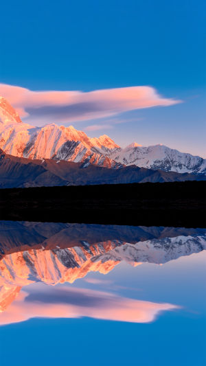
It consists of three almost parallel rows of mountains, with the largest being the Rocky Mountains extending over 4,800 kilometers north to south and averaging between 2,000 and 3,000 meters in elevation. The middle column includes the Alaska Range, Coastal Range in Canada, Cascade Range, and Sierra Nevada Mountains, with Mount McKinley in the Alaska Range being the highest peak in North America at 6,194 meters above sea level.
Between the Eastern and Central Ranges lie highlands and intermountain basins such as the Colorado Plateau and Mexican Plateau, with the Great Basin being the largest.
The western column of the Cordillera is dominated by the Coastal Range in the United States and the Baja California Peninsula extending southward.
These mountains run north to south and form the backbone of North America's topography, blocking most of the water vapor from the Pacific Ocean from penetrating deep into the interior. In contrast, the eastern part of North America is a relatively low plateau and mountainous area, bordered by the St. Lawrence River to the north.
The Labrador Plateau lies north of the St. Lawrence River and mostly sits below 1,000 meters in elevation, covering an area of about 1.4 million square kilometers mainly in the eastern part of Canada. The Appalachian Mountains run northeast-southwest and stretch over 3,000 kilometers in length.
These mountains have lower elevations and allow more Atlantic water vapor to penetrate inland. Along the coast, east of the Appalachians is relatively narrow coastal plains.